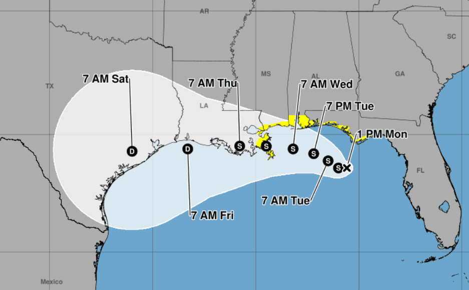
(From NHC 1 p.m. advisory, July 20, 2026)
- Impact from rain and winds expected to be most severe south of Interstate 10.
A tropical depression in the Gulf of America is anticipated to become a tropical storm, bringing rain and flooding potential to the southern portion of Mississippi and into Louisiana this week.
Monday morning, the Mississippi Emergency Management Agency said the depression is currently along the panhandle of Florida and is expected to reach tropical storm status later that same day as it tracks northwest along the Gulf Coast.
MEMA is warning Mississippians that potentially life threatening coastal flooding and flash flooding is expected to occur as the storm moves along that path through the week.
“Areas of flash flooding are possible through Friday along the Gulf Coast and southern Mississippi,” MEMA stated in a social media post.
Jamie Rhome, National Hurricane Center Deputy Director, described during a Monday morning update that the storm is expected to develop slowly into a named storm.
“We do anticipate slow development over the next 24 to 36 hours, potentially bringing this to a tropical storm strength later today or tonight, at which point it would acquire the name Bertha,” Rhome described.
It is expected to reach Mississippi and southeast Louisiana sometime on Wednesday.
Wind hazards across the four states along the Gulf Coast from Florida to Louisiana are anticipated. The three southern most Mississippi counties of Hancock, Harrison and Jackson are included in that forecast.
As of Monday morning, areas from Florida to Louisiana were under a tropical storm watch. Areas from coastal Alabama to Louisiana have also been placed under a storm surge watch, with two to four feet of storm surge potentially causing difficult or life-threatening conditions. Rhome suggests keeping up-to-date with alerts issued by local emergency management offices as the storm progresses northwest over the next few days.
“It doesn’t seem like a lot, but there are some very vulnerable low lying areas in this part of the country,” Rhome warned about the coastal flooding.
The National Weather Service predicts the storm will bring not only strong winds and some storm surge, but also heavy rainfall south of Interstate 10. Rainfall in those areas can cause flash flooding, swelling to rivers, neighboring tributaries, creeks and ditches. Low lying areas will be the most affected.
Wind strong enough to cause damage to porches, awnings, car ports and sheds are possible.
As of Monday, the NWS did not predict impacts from tornadoes as the storm makes landfall.

Jeremy Pittari