- The now-abandoned Mississippi River Basin Model is located just outside of Clinton. The amazingly elaborate scale model is an engineering marvel.
I admit, I like to learn about places that are obscure and sometimes, kind of wacky. With this being the month for all things spooky and creepy, I began thinking of places in Mississippi that fill that bill – and there are plenty, from haunted antebellum homes to cemeteries dating back to the early days of this state.
One place on my “spooky” list rose to the top. The now-abandoned Mississippi River Basin Model is located just outside of Clinton. The amazingly elaborate scale model is an engineering marvel that was beneficial to the study of flooding, and it actually prevented many floods during its use. It was also a tourist destination.
So what exactly was it, and why was it built?
To understand the “why,” it’s important to know a bit of flood history.
The great Mississippi River flood of 1927 was a catastrophic event, displacing over 500,000 people, and destroying thousands of homes and businesses – the result of multiple failed levees. The flood has been reported, romanticized, and reimagined in newspapers, books, and movies. (Rising Tide by John M. Barry; The Tilted World by Tom Franklin and Beth Ann Finnelly; Oh Brother Where Art Thou).
With millions of acres across seven states under water, the financial damage of that flood was the equivalent of $1.3 trillion. At the time, it was the same as one-third of the Federal budget. President Herbert Hoover said it was “the greatest peace-time calamity in the history of the country.”
New levees were built. Laws concerning their construction were passed. Yet, there was clearly a problem, because it happened again ten years later. A solution in one place created a flooding problem in another. As complex as the Mississippi River is, engineers realized they needed to look at the problem as a whole instead of handling issues on a place-by-place basis.
Building a model of the entire Mississippi River would provide a way for engineers to see what would happen to the river under different circumstances.
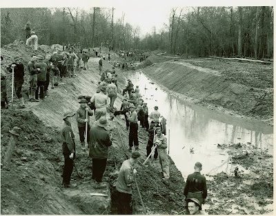
Before computers were able to do the tasks they can now, engineers relied on elaborate models of complex systems – scale models that replicated in detail what they wanted to study. In this case, it was the Mississippi River Basin. The model was built in the 1930s under the direction of the Army Corps of Engineers. They had built many models prior to this one, but their scale-model of the Mississippi River Basin was the largest model ever built.
To put it into perspective, the model represented 41% of the United States in miniature – with more than 15,000 miles of rivers. The waterways snaked their way around the 200 acres of park land – with eight miles of winding streams.
Because construction began in 1943, the Army Corps of Engineers had to get creative. Manpower was short during World War II, so they used available labor provided by prisoners of war housed at Camp Clinton. The facility was home to 3,000 Italian and German POWs, and many were selected to work on the project due to their engineering skills.
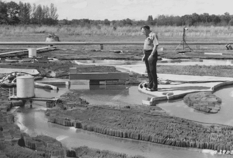
The plan was to complete the project by early 1949, but because it was the most ambitious research project the Army Corps had ever undertaken, it wasn’t finished until 26 years after it was started. Parts of the model were used as early as 1949, but it wasn’t fully finished until 1966.
In all, there were 79 simulations run in the model, lasting anywhere from weeks to months, designed to learn more on how to predict and respond to flooding and other hydraulic disasters in our country’s waterways. There were successes along the way, including avoiding major flooding in Omaha in 1952 by using information gathered from the model. It is estimated that $65 million in damages was avoided.
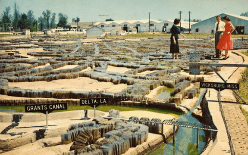
The incredible engineering feat became a destination for tourists. For a few years over 5,000 people toured the model each year, like so many giants towering over the banks of the Mississippi River in miniature.
When computer modeling began in the early 1970’s the Mississippi River Basin Model began its decline into obsolescence. By the 1980s, the Army Corps of Engineers began to view the model as a burden.
They pulled out of the project in 1990 and the site at Billy Butts Park was transferred to the City of Jackson in June 1993. The park, located off I-20 at 7 McRaven Road in Southeast Jackson, now features a soccer complex, restrooms, picnic area, disc golf course and more. Because the basin model was so expensive to maintain, the City abandoned it.
The model appeared on the Mississippi Heritage Trusts’ Ten Most Endangered List almost 25 years ago. A group of interested citizens who call themselves Friends of the Mississippi River Basin Model formed to clean up the site in the last decade, with the hopes of renewing Buddy Butts Park, and to enhance educational opportunities for children in Mississippi. Read more about their work and the history of the project on their website.
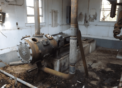
The remains of the model are open to the public to visit, but the model is overgrown and the gate is often locked. To add to the spooky feeling, several abandoned and vandalized buildings are on the property, including one that housed the huge hydraulic pumps for the model.

Susan Marquez