(From FEMA Flood Map Services Center)
- Residents in the affected areas can review the new flood maps at their county or municipal offices.
According to filings on the Federal Registry, the Federal Emergency Management Agency (FEMA) has finalized flood hazard determinations for several communities in Mississippi while issuing a notice regarding changes to determinations for another.
FEMA said the determinations, which may include additions or modifications of Base Flood Elevations (BFEs), base flood depths, Special Flood Hazard Area (SFHA) boundaries or zone designations, or regulatory floodways on the Flood Insurance Rate Maps (FIRMs) have been made final for the following Mississippi communities:
- Chickasaw, Clay, Itawamba, Lee, Lowndes, Monroe, Prentiss, and Tishomingo counties
- Cities and/or towns of Okolona, Tremont, Baldwyn, Columbus, Aberdeen, Amory, Smithville, Booneville, Belmont, Tishomingo, and Paden
The updated FIRMs impact flood management measures in these areas local officials will be required to adopt the new determinations to remain qualified for FEMA’s National Flood Insurance Program (NFIP).
FEMA said these new determinations are effective starting November 28, 2025.
Residents in these areas can review the new flood maps at their county or municipal offices or online when updated at the FEMA Map Service Center.
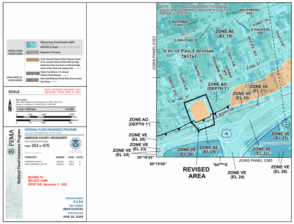
The other notice issued by FEMA on the Federal Registry concerns the City of Pass Christian where the agency has put forward changes to the municipality’s flood hazard determinations.
FEMA said the changes involve BFEs, SFHA boundaries, and other designations shown on the latest FIRMs in the Coast city listed as “Gulf of America to Mississippi Sound – an area centered at approximately 800 feet northwest of the intersection of Old Coast Road and Vanderbilt Drive.”
“We based this determination on the 1-percent-annual-chance (base) stillwater elevations computed in the FIS for your community,” FEMA’s Letter of Map Revision sent to the city noted. “A comprehensive restudy of your community’s flood hazards could establish greater flood hazards in this area.”
FEMA said the updated flood hazard information will be finalized on September 11, 2025.
Residents have 90 days in which to request through the community that the Deputy Associate Administrator for Insurance and Mitigation reconsider the changes. The flood hazard determination information may be changed during the 90-day period.
To learn more about this change in Pass Christian, visit the FEMA Map Services Center here.